Thomas Suárez Rare Maps
London ● (+44) 079.1913.0779 ● suarezmaps@gmail.com
from the USA: (+1) 646.593.7771
London ● (+44) 079.1913.0779 ● suarezmaps@gmail.com
from the USA: (+1) 646.593.7771

INDIA
Lorenz Fries, 1522 (1525)
$ 450
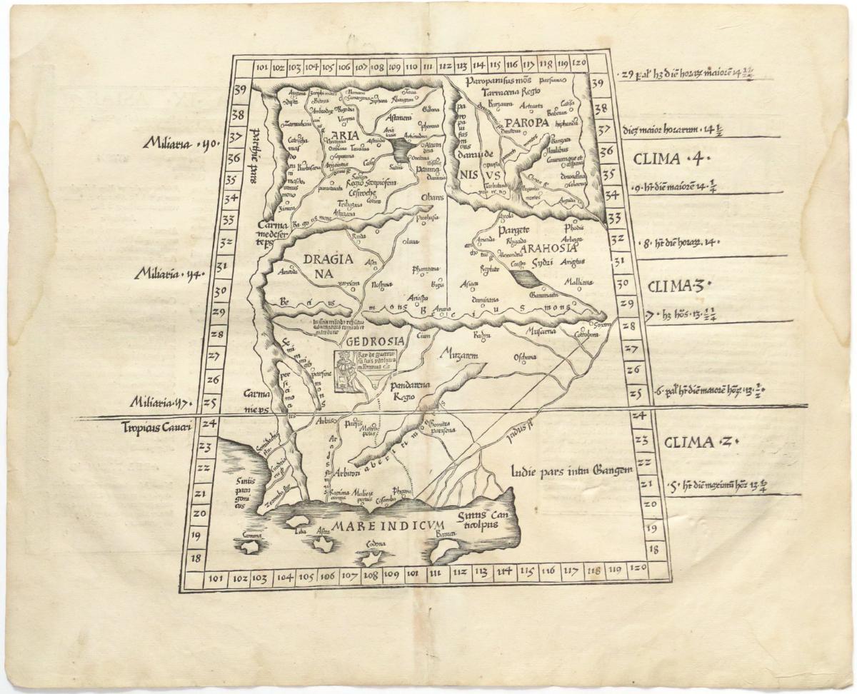
INDIA & PAKISTAN
Lorenz Fries, 1522 (1525)
$ 350
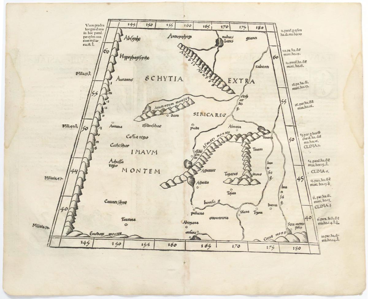
CENTRAL ASIA
Lorenz Fries, 1522 (1525)
$ 300

The First Printed Map to focus on China and Japan
Lorenz Fries. A few examples of different editions are available, 1525, 1535, 1541 - please inquire

The First Printed Map to focus on Southeast Asia
Lorenz Fries. A few examples of different editions are available, 1525, 1535, 1541 - please inquire.
Although the atlas prepared in 1522 by Lorenz Fries was for the most part copied from the 1513 atlas of Waldseemuller, this map was not part of that earlier work and is the creation of Fries himself. The sources material, nonetheless, remains the eminent Waldseemuller, probably the separately-published world map of 1507. Waldseemuller, in turn, drew largely from such fifteenth-century sources as Martellus.
This woodcut map of Malaya and the East Indian islands is a landmark for the region, being the first specifically devoted to Southeast Asia.

Sumatra (?) (functioning as)
Scilam.
Bordone, 1534
$ 200

SUMATRA (top) and various Indian Ocean islands
Bordone, 1528 (first issue)
$ 350

"Ship of China and Java with rattan sails and wooden anchor"
Linschoten, 1596.
Excellent. 10 x 12.5 in / 25 x 32 cm
$ 465

CHINA, MANDARINS
Linschoten, 1596.
Excellent. 10 x 12.5 in / 25 x 32 cm
$350
THE FAMOUS MARKET AT BANTAN
Linschoten / de Bry, 1599
Sold as is: As visible, margin added on left, right side clipped, and top is ratty. View itself is 7.5 x 14 in / 18.5 x 35 cm
$ 145

ASIA, JAPAN, AMERICAN NORTHWEST
Tartaria sive magni chami regni typus
Pietro Marchetti, 1598
From the rare Theatro del mondo of Pietro Marchetti, printed in Brescia, based on the map made by Philipp Galle for the Ortelius Epitome.
The map itself is 3 x 4 inches, on a full sheet about 8 x 6 inches.
$ 250

Early miniature Japan, Based on Teixeira
Langenes, 1598 (1606)
$ 350.
Based on the Teixeir model as popularized by Ortelius just three year earlier. This map, derived by Ortelius from the Portuguese Jesuit Luis Teixiera, was the first map to correctly locate Japan between 30 and 40 degrees north latitude, and in its basic accuracy it was nothing short of revolutionary.
Teixieras map is also interesting in that it was born of two worlds. Information for its construction was derived both from Jesuit sources and from the native Gyogi maps (Gyogi, in Japanese tradition, was their first cartographer). Manuscript maps which survive in Florence and Madrid bear close generic resemblance to Teixiera's; he probably knew these, others similar, or their Gyogi prototypes. It was probably from these manuscript maps that Teixiera was able to delineate and label the 62 kuni (political units) into which Japan was then divided. See: OAG 7.

SOUTHEAST ASIA
Jodocus Hondius, 1606 (Latin, 1630)
Excellent, wide margins (not shown), original color. 13.5 x 18.5 in / 34.5 x 47 cm.
$ 3500
Hondius' Insulæ Indiæ Orientalis is one of few maps to show any trace of Francis Drake’s presence in Southeast Asia. Hondius had spent several years in London, having fled there in about 1583 to avoid religious persecution. At that time, Francis Drake’s flamboyant circumnavigation was still fresh news, and Hondius (as we know from other maps he made) became well-acquainted with the voyage. Drake is believed to have taken with him a sea chart prepared by a Lisbon maker, possibly Vaz Dourado. To this manuscript chart and other printed materials, he added Iberian sea charts and pilot books, plundered en route. Like Magellan, his only predecessor in circumnavigation, Drake’s first landfall in Southeast Asia was some point in Micronesia (the precise landfall is calmly disputed, though Palau is the likely candidate). Unlike Magellan, he had set off across the Pacific from some point in North America (that landfall is hotly disputed). From Micronesia he continued west to Mindanao, then sailed southeast in search of the Spiceries. He picked up two native fishermen in canoes in the seas somewhere northeast of Sulawesi, who guided him to the Moluccas. Leaving the Moluccas filled with spices and the precious spoils of earlier plunder in South America, Drake attempted to navigate the tricky waters leading to the clearer seas to the south, but ran aground on a steep reef off Sulawesi. Three tons of cloves, among other valuables, were dumped overboard to lessen their weight, but nothing seemed to help them from what appeared to be inescapable disaster until the strong winds reversed, freeing them from the reef. Hondius seems to recognize the fact that the eastern Sulawesi coastline was far more complex than current charts showed. Although he does not know what configuration to give the island, he ‘ripples’ the eastern shores of Sulawesi in a more pronounced fashion than de Lasso, acknowledging that there were significant, though unknown, undulations in the coast, such as that which befouled Drake.

as above, French edition of 1619
Original color, heightened in gold, wide margins
$ 4200

NEW GUINEA AND THE SOLOMONS
Nova Guinea et Ins. Salomonis
Petrus Bertius, 1616
$ 365


VIETNAM, SOUTH CHINA SEA
Jean Baptiste Tavernier, 1682
$ 750.
NEW ZEALAND AND THE SOLOMONS
Mallet, 1683 / (1684?)
Modern color.
$ 145

MICRONESIA AND THE PHILIPPINES
Inselin, 1705, Carte des nouvelles Philippines découvertes sous les auspices de Philippe V, roy d'Espagne
7.5 x 8.25 in / 19 x 21 cm
$ 125

Southern India
Joseph Stocklein, from Der Neue Welt Bott, 1726-1728
Sud-Theil von Indien Herwerts des Ganges Autore R.P. Ioan Venantio Buichet e. Soc. Iesu.
Excellent.
$125.

Carnate (India)
Joseph Stocklein, from Der Neue Welt Bott, 1726-1728
Iter R. Patris Mauduit Galli e S.I. ab Ora Coromandeli per Regnum Carnate a 3. Sept. 1701.
Excellent.
$ 45.

Nagasaki
Joseph Stocklein, from Der Neue Welt Bott, 1726-1728
Nangasaki so die Sineser Tschangki nennen.
Excellent.
$85.

Micronesia, Philippines
Joseph Stocklein, from Der Neue Welt Bott, 1726-1728
Insulae Palaos.
Excellent.
$350

The martyrdom of Ioannes Baptista Messari in Vietnam
Joseph Stocklein, from Der Neue Welt Bott, 1726-1728
Trimmed on lower left.
$150.
 THAILAND
"Rappresentazione del vestito del Popolo di Siam" Giuseppe Filosi (engraver), from Lo Stato Presente di Tutti i Paesi e Popoli del Mondo Naturale, Naples, 1738.
Image itself without caption: 6.5 a 7.25 in / 16 x 18.5 cm. Modern color.
$ 65
 Southern Asia
Johann Christoph Steinberger, 1775
$100


First Hawaiian to enlist aboard a European ship
from Meares, 1791
Excellent, with wide orignal margins (not shown). Modern color.
Image itself, without caption, is 6 x 9 in / 15.5 x 12.5 cm.
The pair, with Tianna, below: $ 465.
Winée (or Wynee) was the first Native Hawaiian from the Hawaiian Islands to travel abroad on a Western ship. She traveled to British Columbia and China before dying on the voyage home to Hawaii.
Winée was originally from the "big" island of Hawaii. In 1787, she became the first Native Hawaiian to sail abroad with a Western ship when she was hired as the servant or maid of Frances Hornsby Trevor Barkley, the wife of Captain Charles William Barkley, on the British ship Imperial Eagle. Barkley recorded her name as Wynee which was possibly an attempted spelling of wahine, the Hawaiian word for woman. She traveled to the Pacific Northwest and later to China.
The Barkleys intended to take her back to Europe but Wynee requested to return home and so she was left in the Portuguese colony of Macao. At Canton, she arranged to return to Hawaii aboard Captain John Meares's ship Felice Adventurero with fellow Hawaiian "Tianna" (Kaʻiana – also spelled Tyaana & Tyanna), a member of the aliʻi (high chief) class from the island of Kauai. Traveling with them were two other Hawaiians: a stout man and a boy from Maui but they are not specifically named.
But on February 5, 1788, Winée died of illness on the voyage home. Tianna, who remained by her bedside caring for her, contracted a fever as well. He reportedly became seriously distraught upon learning of her death, although he would recover and arrive back home. Wynee bequeathed to him some trade articles she had acquired and asked him to deliver her remaining possessions to her father and mother; these items included mirrors, porcelain, Western clothing and other items she collected during her travel. She was buried at sea.

Hawaiian "prince of Maui", accompanied European ship and Wynee (see above)
from Meares, 1791
Excellent, with wide orignal margins (not shown). Modern color.
Image itself, without caption, is 6 x 9 in / 15.5 x 12.5 cm.
The pair, with Winée, above: $ 465.

Laurie & Whittle, 1794 "A New Chart of the North Coast of Java"
58 x 89 cm / 23 x 35 in
$ 1500

Views of Manila from La Perouse's voyage
First edition, 1797.
Baie de Manille $ 350
Costumes des Habitans $ 250

LARGE-SCALE CHART OF EASTERN INDONESIAN ISLANDS
Laurie & Whittle, London, 12th Oct 1798: A New Chart of the Eastern Straits or the Straits to the East of Java, with a part of the Banda Sea. Corrected and Improved, chiefly from the Observations of Captin. R. Williams.
47 by 64 cm / 18.5 x 25.3 in
$ 1500

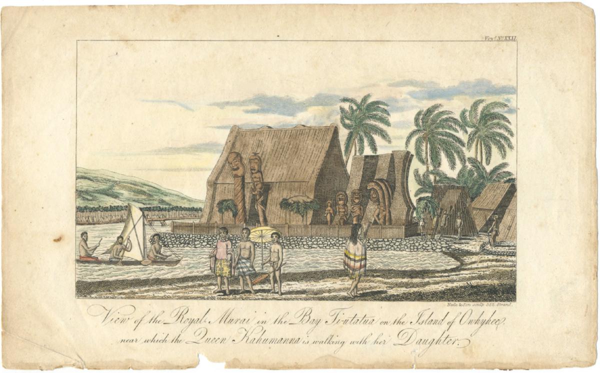 Otto von Kotzebue, from "Voyage of discovery in the South Seas, and to Behring Straits", London, Sir Richard Phillips and Co., 1821
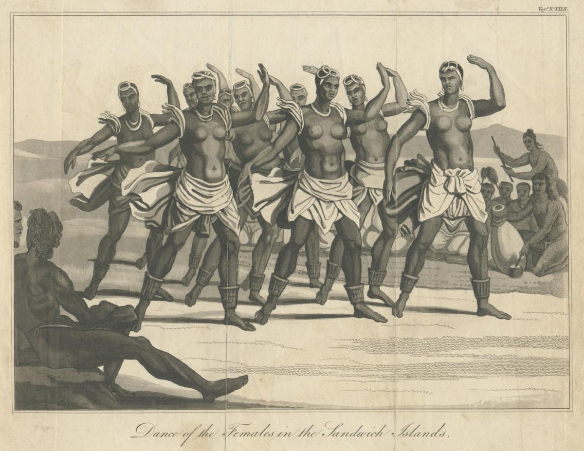
Fold-out plate of women performing a dance in Hawaii
Otto von Kotzebue, from "Voyage of discovery in the South Seas, and to Behring Straits", London, Sir Richard Phillips and Co., 1821
6.75 x 9.25 / 17 x 24 cm image itself, without caption
$ 225.

RATAK ISLAND (Marshalls)
Otto von Kotzebue, from "Voyage of discovery in the South Seas, and to Behring Straits", London, Sir Richard Phillips and Co., 1821
3.5 x 7 in / 9 x 18 cm not including title.
$ 25

HAWAII
Otto von Kotzebue, from "Voyage of discovery in the South Seas, and to Behring Straits", London, Sir Richard Phillips and Co., 1821
4 x 7 in / 10.5 x 17.5 cm not including title. Modern color.
$ 55


Tallis, c1851. Original outline color on the geography, modern color on the vignettes.
$ 125

Levasseur, c 1860
Original outline color on the geography, modern color on the vignettes.
$ 125.

Pillon, c1850
Original sparse outline color.
$ 75